GAMA-Platform

GAMA-Platform

  • Documentation
  • Tutorials
  • Download
  • Contribute
  • Blog

›Road Traffic

Tutorials

  • Tutorials

Predator Prey

  • Predator Prey
  • 1. Basic Model
  • 2. Vegetation Dynamic
  • 3. Prey Agent Behavior
  • 4. Inspectors and Monitors
  • 5. Predator Agent
  • 6. Breeding
  • 7. Agent Aspect
  • 8. Complex Behavior
  • 9. Stopping condition
  • 10. Charts
  • 11. Writing Files
  • 12. Image loading
  • 13. Model exploration

Road Traffic

  • Road Traffic
  • 1. Loading of GIS Data
  • 2. People Agents
  • 3. Movement of People
  • 4. Weight for Road Network
  • 5. Dynamic weights
  • 6. Charts
  • 7. Automatic Road Repair

3D Tutorial

  • 3D Tutorial
  • 1. Basic Model
  • 2. Moving Cells
  • 3. Connections

Incremental Model

  • Incremental Model
  • 1. Simple SI Model
  • 2. Charts
  • 3. Integration of GIS Data
  • 4. Movement on Graph
  • 5. Visualizing in 3D
  • 6. Multi-Level
  • 7. Differential Equations

Luneray's flu

  • Luneray's flu
  • 1. Creation of a first basic disease spreading model
  • 2. Definition of monitors and chart outputs
  • 3. Importation of GIS data
  • 4. Use of a graph to constraint the movements of people
  • 5. Definition of 3D displays
  • 6. Exploration of the model

BDI Agents

  • BDI Agents
  • 1. Skeleton model
  • 2. BDI Agents
  • 3. Social relation
  • 4. Emotions and Personality
  • 5. Norms, obligation, and enforcement

Road Traffic

This tutorial has for goal to present the use of GIS data and complex geometries. In particular, this tutorial shows how to load gis data, to agentify them and to use a network of polylines to constraint the movement of agents. All the files related to this tutorial (shapefiles and models) are available in the Library models (Tutorials, Road Traffic).

If you are not familiar with agent-based models or GAMA, we advise you to have a look at the prey-predator model first.

Model Overview

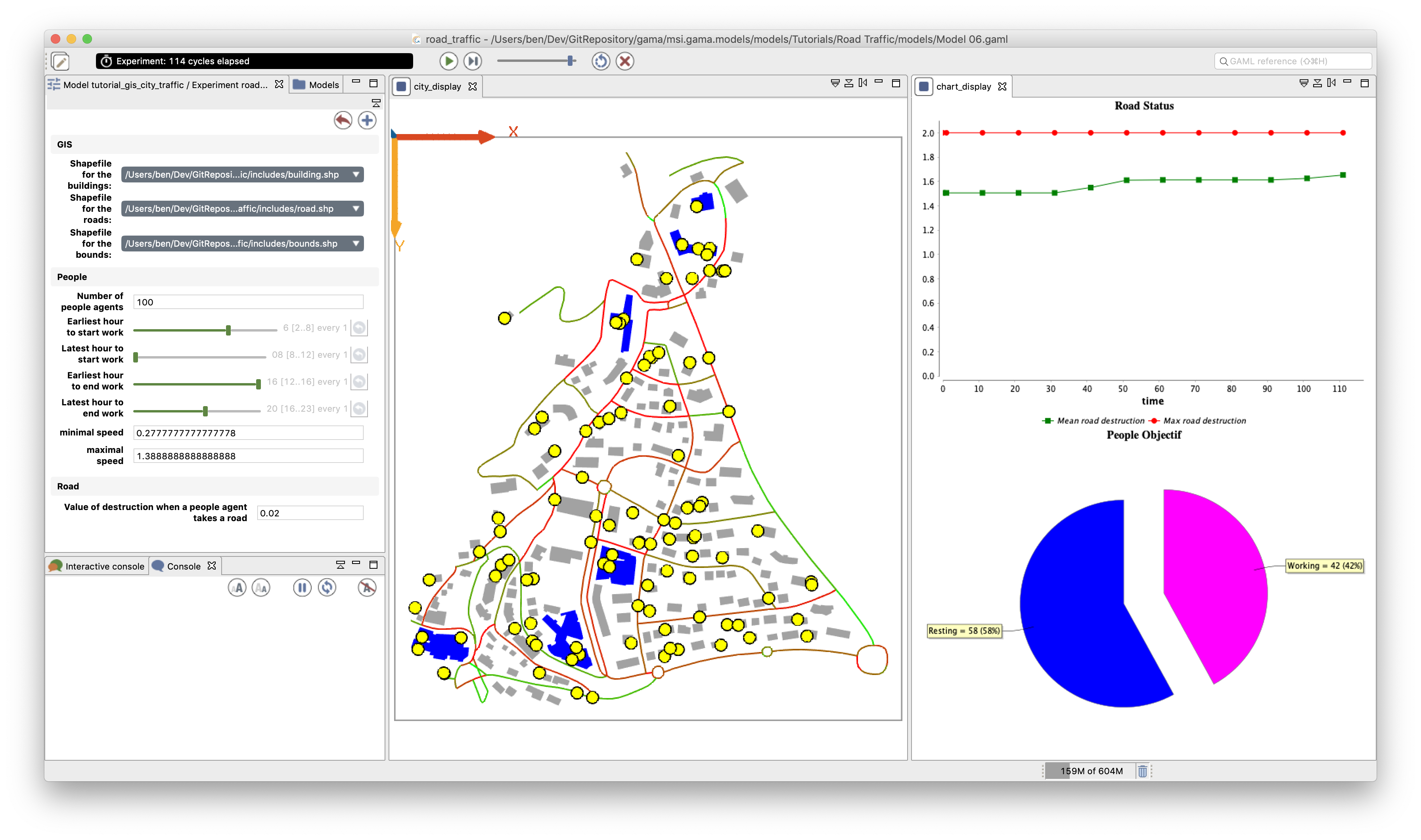
The model built in this tutorial concerns the study of road traffic in a small city. Two layers of GIS data are used: a road layer (polylines) and a building layer (polygons). The building GIS data contain an attribute: the 'NATURE' of each building: a building can be either 'Residential' or 'Industrial'. In this model, people agents are moving along the road network. Each morning, they are going to an industrial building to work, and each night they are coming back home. Each time a people agent takes a road, it wears it out. More a road is worn out, more a people agent takes time to go all over it. The town council is able to repair some roads.

Road traffic tutorial: a screenshot of the final state of the model.

Step List

This tutorial is composed of 7 steps corresponding to 7 models. For each step, we present its purpose, an explicit formulation, and the corresponding GAML code.

  1. Loading of GIS data (buildings and roads)
  2. Definition of people agents
  3. Movement of the people agents
  4. Definition of weight for the road network
  5. Dynamic update of the road network
  6. Definition of a chart display
  7. Automatic repair of roads
← 13. Model exploration1. Loading of GIS Data →
  • Model Overview
  • Step List
GAMA-Platform
Networks
GitHub Facebook Twitter LinkedIn Youtube Blog RSS
Mailing list
For Users
gama-platform@googlegroups.com
For Developers
gama-dev@googlegroups.com
License

Copyright (C) - 2019 GAMA-Platform.

Permission is granted to copy, distribute and/or modify this document under the terms of the GNU Free Documentation License, Version 1.3 or any later version published by the Free Software Foundation; with no Invariant Sections, no Front-Cover Texts, and no Back-Cover Texts.

A copy of the license is included here, in the repository of the wiki content.